 Site organization
1.
Numbers and hyperlinks
Clicking on a number on the tour map will
take you to the map of the corresponding tour or city. There are but a
few hyperlinks leading to the world outside the site, thus reducing the
chance of being frustrated by an outdated or inactive URL. However, several
towns have their own website that you are kindly invited to visit.
2.
The tour maps
The main tour is indicated in
blue
(red indicates heavy
traffic roads) and the alternatives in
green.
Checkered sections correspond to unpaved roads on the tour. The colour
grey
indicates
an unpaved road that is not on the tour. A brownish
hue
designates railroads. The green disk  shows the start of the tour; the red disks
  show subsequent stages. Black disks
  indicate variants, while pink ones
  correspond to roads whose long names are shown on a light green window
within the map.
3.
Distances
Distances, which are given in international units
(kilometers), are only accurate to 10 meters, due to the limitation of
my odometer. One mile is exactly 1.609344 kilometer.
4. Total climb
Computed using the site Bikely.com,
these figures are anything but reliable.
5.
Icons
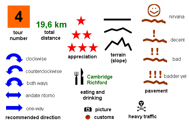
The meaning of the icons is explained below. My appreciations
are subjective and only represent an average over a tour.
Some tours are better travelled in the direction:indicated
by the blue arrow. If both directions are worthwile, the blue arrow has
two heads. A flat arrow corresponds to a one-way journey.
6. Navigation
 |
Thumbnails of pictures, produced with
irfanview. |
 |
Return to map of tours and cities. |
 | Clicking
on the image yields a KML file that you can download and visualize in
Google Earth, if the latter software has been installed, of course. |
 |
Map of the tour. |
 |
MapMyRide version of the tour (satellite,
topo, and OSM overlays). Note that the elevation data is unreliable. The link posted gives you direct access to the fullscreen version, for instance www.mapmyride.com/routes/fullscreen/421543494/. To go to the home screen, simply replace fullscreen by view in the URL, for instance: www.mapmyride.com/routes/view/421543494/. Among other goodies, this gives you access to a virtual 3D tour of the circuit. Towards the left of the page, a cue sheet
can be accessed by clicking on "Directions/Notes". There is also the
option of creating .GPX files compatible with Strava, Garmint, or other
online apps. |
 |
Map of corresponding city. |
 |
Burlington weather forecast. |
 |
Iberville Weather forecast. |
|
 Site organization


